I use Google Maps quite a bit, and seldom for finding my way. Normally, I use it in satellite mode to look for large geological formations, such as meteor craters.
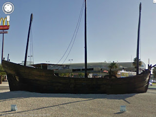
One thing I had never thought of using it for was maritime research on an individual ship. In this case, the vessel is a replica of the Niña, based upon the work of Professor Luis M. Coín Cuenca, Cadiz. This is replica has fascinated me since I read about it in the late John Dyson's "Columbus: For Gold, God & Glory". I won't go into the book, as it deals with something of a controversial subject ("The Unknown Pilot"). The Niña used in this book (and television special) was built in the early 1990's, and subsequently sailed across the Ocean Sea; it graces the book's cover.
I lost track of the ship in my research very early, knowing that while it did make it across, the question was did it sail back?
My reason for being interested in it has to do with its design. This Niña is very lightly built, almost an open boat (an old theory about Columbus' caravels, long since discredited for over a century and a half). It looks almost frail, and compared to the Sarsfield Niña/Santa Clara, is downright small.
Nevertheless, it is still a caravel, and true to my nature, must be researched.
Enter Google Maps.
I decided to look up the aforementioned book, and re-discovered the historian involved, Professor Coín Cuenca. After that, it was a matter of time.
I found a picture during a search. It was somewhere in El Puerto de Santa Maria, Spain. Once the location was pinned down, I used Google Maps to locate the caravel.
She was located in a traffic roundabout on the N-IV, on the south side of the Rio Guadalete.
This is where the research comes in. The overhead satellite view gives us the deck layout -
Google indicates that there are plenty of images from the location, but instead I chose to use Google Street View to "drive" around the caravel and get images -
(Side note - I can't help but marvel at how much this part of Spain looks like south Florida!)
These images, combined with information gleaned from the City of El Puerto de Santa Maria's website, give us a better idea of the vessel. This particular replica Niña is 21 meters long, 5 meters in beam; 68' 10 3/4" in length overall, 16' 4 7/8" in beam.
There is still some more research needed, and with any luck I will be able to reach out to Prof. Coín Cuenca for more information.
One thing to keep in mind; when the images are first pulled up in Street View, there is a bit of distortion. The moment you begin to zoom in, the distortion is minimized; you are going from a forced wide-angle image to a more standard view.
One thing to keep in mind; when the images are first pulled up in Street View, there is a bit of distortion. The moment you begin to zoom in, the distortion is minimized; you are going from a forced wide-angle image to a more standard view.
In the mean time, the images gained give us a little more information as to how this little caravel appears. They may not be blueprints, but they provide us with more insight into this small caravel.
It also provides us with another use for the maps program in basic research, lacking the means to be there ourselves.


No comments:
Post a Comment